


Updated: Thursday 1:12 p.m.
The most recent update from Chatham County on Hurricane Dorian:
PITTSBORO — Chatham County Emergency Management leaders are keeping a close watch on the path of Hurricane Dorian as the storm churns its way up the Southeastern United States and closer to North Carolina.
Tropical storm conditions will affect central North Carolina, including Chatham County, and conditions are expected to deteriorate Thursday afternoon and evening. As of 11:30 a.m. Thursday, a Tropical Storm Watch was in effect for Chatham County and Tropical Storm Warnings and Flash Flood Watches were in effect for counties east of Chatham County. The threat for Tropical-storm-force wind/wind gusts is greatest across central North Carolina between 2:00 p.m. Thursday through 6:00 a.m. Friday.
“Chatham County Emergency Management continues to monitor storm conditions and impacts throughout our county as well as coordinate with our partners and stakeholders,” said Steve Newton, director, Chatham County Emergency Management. “Since we expect a reduced impact in Chatham County, we have deployed personnel and equipment to other communities in need. Chatham County and its municipalities currently have personnel at a North Carolina Emergency Management Regional Coordination Center, the State's Regional Shelter in Durham and on the way to Chowan County. We have deployed equipment to Edgecombe and Durham Counties.”
Know the difference between a watch and a warning
A Tropical Storm Watch means tropical storm conditions (sustained winds of 39 to 73 mph) are possible within the specified area within 48 hours. A Tropical Storm Warning means storm conditions (sustained winds of 39 to 73 mph) are expected within he specified area within 36 hours. A Flood Watch is issued when flooding is possible. A Flood Warning is issued when flooding is happening or will happen soon.
Residents should stay aware
In addition to monitoring local weather reports, residents are encouraged to stay alert through Chatham County CodeRED: https://public.coderedweb.com/cne/en-US/600C00D297C7. Those who sign up will get alerts by text message when dangerous conditions are in the area. Participants can add as many phones as they like and customize the types of alerts they want to receive.
Residents should prepare
Being prepared for Dorian and other storms includes the following:
Have important supplies on hand before they disappear from the shelves:
Important food supplies include:
Update: Thursday, 9:09 a.m.
The outer bands of Hurricane Dorian reached the coast of North Carolina this morning. Dorian increased in strength slightly overnight, growing to a Category 3 hurricane though its track changed little. The National Weather Service in Raleigh reports that "conditions will deteriorate rapidly late this morning and through the afternoon."
All campuses for Central Carolina Community College are closed today in anticipation of the storm. Chatham County Schools will be closing two hours early as well to allow for buses and student drivers to make their way before the worst of the storm hits.
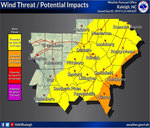
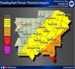
While the greatest impacts are expected east of I-95, the latest briefing from the National Weather Service indicates that the wind and localized flooding threat for Chatham County have moved slightly west, impacting more of the county. Simulations created by the National Weather Service indicate that the greatest impact to our area will occur overnight.
Wednesday, 10:31 a.m.
Chatham County officials are on alert after North Carolina issued a State of Emergency declaration on Sunday in advance of the arrival of Hurricane Dorian.
In the statement, Gov. Roy Cooper “urged North Carolinians today to pay close attention to Hurricane Dorian, and make sure they are ready for its possible impacts expected by the middle of the week.”
“North Carolina has endured flooding from two strong hurricanes in less than three years,” Cooper said. “Now is the time to prepare for Dorian. To the people of North Carolina, particularly those still recovering in the eastern part of our state, we are working hard to prepare and we are with you.”
The National Weather Service declared Hurricane Dorian a Category 5 storm but it has since deteriorated to a Category 2 though the storm's width has expanded. The storm's forecasted track will keep the storm close to the Carolina coastline. Though the track is still subject to change, the National Weather Service urges residents to begin necessary preparations now and have them complete by nightfall on Wednesday.
According to the 7 a.m. Wednesday briefing from that National Weather Service in Raleigh, Hurricane Dorian's "overall timing through Central N.C. has slowed down." The threat for tropical-storm-force wind gusts has increased across central N.C., but the threat for damaging winds decreases from Raleigh westward. Pittsboro is expected to have wind of 29 miles per hour with gusts up to 57 miles per hour. Pittsboro can also expect localized flooding from the storm though the Haw River and the Deep River are not expected to reach flood stage.
"The most likely time southern and eastern portions of NC could start seeing tropical-storm-force winds is Thursday morning into the afternoon," the National Weather Service in Raleigh's briefing said.
Chatham County Emergency Management and the Chatham County Sheriff’s Office are watching the storm closely and have the
Emergency Operation Center, a communication system for emergency services, on stand-by if needed. Chatham County Emergency
Management Specialist Colby Sawyer said that Dorian appears to be “mainly a coastal storm unless something dramatically changes.” The area will likely still see tropical storm force wind gusts and rain with nuisance flooding.
“We are watching the situation closely and will be watching the county so that if anything happens we can identify and address it,” Sawyer said.
Though Chatham County may not see the eye of the storm, Sawyer urges residents to be prepared.
“This is a great reminder that folks need to be prepared year-round,” Sawyer said. “Though we may not be getting a direct hit from a Category 5 storm, we will still feel effects. Let this be the impetus for getting prepared and if nothing happens then, great, you’re prepared for next time.”
Chatham County Sheriff Mike Roberson also noted that if the storm tracks continues more along the coastline than inland, some first responders and emergency management officials in Chatham County may travel to the worst damaged areas of North Carolina to assist there following the storm.
Updates on Emergency Services can be found in numerous ways. Residents can sign up for ALERT Chatham, and monitor the Chatham County Emergency Management Facebook and Twitter accounts. The National Weather Service in Raleigh also hosts a YouTube channel (www.youtube.com/NWSRaleigh) that airs emergency briefings throughout major weather events.
The Chatham News + Record will be updating regularly on the storm and its aftermath.
Reporter Casey Mann can be reached at caseymann@chathamnr.com.